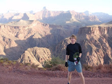
 Today I took a field trip to the Verde Valley with my Evolution of Sedimentary Basins class. The geology of this area is pretty interesting. This particular photo above is looking west from I-17 into the valley itself. Our question was, is the verde valley (in part) an active sedimentary basin, is it inactive, or is it even a basin at all...lets find out shall we?
 We start a pull off (same as above) and learn that much of what we see, including what we are standing on, are basalt flows. These flows moved in a southerly direction on the east side of the Verde Valley. These flows are around 6 million years old.
 This is Beavertail (early Tertiary) making up the backdrop of a shootin' range...not to be confused with a shooting range. Conglomerates, siltstone, some marly carbonates. Basalts can be seen capping this formation across the gulch to the right of the camera shot. That's the whole class....except Umhoefer.
 Crossbeds in the Verde Formation (later Tertiary)
 Welcome to Jerome. Located on the west side of the Verde Valley this Copper mining town gone artsy community was gearing up for an art walk the following day. See the car in the foreground...no? How about this:
Yep...
 " The Black Hills disappear to the north as the Verde fault splays." The Verde River flows on the edge of the Verde Formation in and around Quaternary deposits. The lack of these recent sediments indicate the basin is inactive, that and other issues such as fault scarps. Jerome in the background Rory, Paul, Doug, Beau, and Sarah in the foreground.
 A look at Verde Valley to the East. Storm clouds starting to form.
 At the end of the trip we took the back way out of Sedona up the Schnebly Road. Look at those awesome red rocks. I believe this is part of the Hermit Formation...notice the bed of limestone in the foreground. Rain off in the distance over Sedona.
Up the Schnebly Hill road, notice the white sandstone (Coconino). Wisconsin people aren't very good drivers (and they like to run red lights).
 One last shot of the rocks, Oak Creek Canyon exits here. The lightning show was amazing.
1 comment:
THIS IS EXACTLY WHAT I WAS TALKING ABOUT! THE VOLCANIC HILLS, OAK CREEK CANYON (ANOTHER FABULOUSLY BEAUTIFUL PLACE) THEN OUT TO SEDONA AND THE RED TOWERS THERE. WHAT A CHANGE IN AN HOURS DRIVE! IF YOU EVER GO AS FAR NORTH AS LAKE POWELL, PAGE, AZ, IN MY OPINION THAT AREA IS MORE LIKE A MOON SCAPE, OR WHAT I WOULD THINK IT WOULD LOOK. THEN THE SUPERSTITION MOUNTAINS OUT OF PHOENIX. SOUTH OF PHOENIX TOWARDS MEXICO IS PRETTY BORING SCENIC WISE, BUT DURING WWII THERE WAS A GERMAN POW CAMP THERE. THERE WERE NO FENCES BECAUSE IF SOMEONE CAME UP MISSING, THEY WOULD WAIT A FEW HOURS AND THEN GO OUT AND PICK HIS NEARLY DEAD BODY OUT OF THE DESERT. DON'T KNOW IF THIS IS TRUE OR NOT, BUT I DO KNOW THAT NO ONE EVER ESCAPED. SO BE CAREFUL HIKING AROUND OUT THERE. YOU PROBABLY KEEP A GPS WITH YOU, I HOPE. ANABEL
Post a Comment